


Audits - Assessments - Reports
Photo-Documentation Of Assets Conditions, Integration, Performance, Accumulation, Safety, Potential Liabilities... Thermal Imagery, Aerial Scans, Scope Sensors, Technical Reproductions...

Drone Inspections
Generate Statistical Data
Abate Financial Liabilities
Document Mechanical Integrity
Quick Survey Of Overall Situations

Thermal Imagery
Trace Overheating Circuits
Scout, Search, And Rescue
Fast Discovery Of Energy Leaks
Determine Unseen Water Damages

Photo Enhancement
Present Colorful Stories
Improve Impact And Definition
Increase Marketing Assets Value
Block And Pixel Level Manipulation

Commercial Photography
Show Project's Progression
Construct A Historical Portfolio
Monitor Contractor's Performance
Evidence For Claims Or Litigation

Video Imagery
Report Active News
Offer Products And Services
Observe Distribution Logistics
Track Business And Civil Activities

Economically Effective
Non-Intrusive-Non-Destructive
Cheap Situational Assessment
Simple, Precise, And Permanent
Selective And Irrefutable Evidence
Aerial Sample
The Drone Capability Is Impressive!
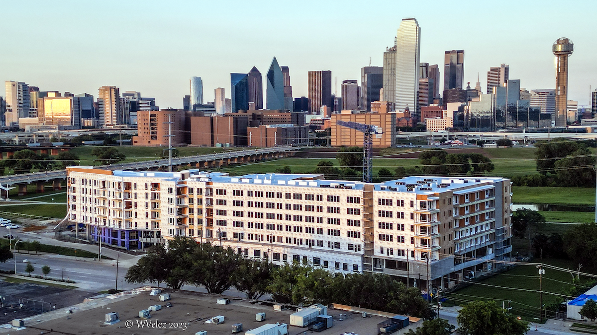
Great effort is taken to plan the flight and time the scene to reduce shadows, center the image, discover the most representative perspective, record at the proper altitude, execute close-ups on concerning spots, and land the aircraft safely, with minimum interruption to your business. All images are reviewed on a large screen for clarity and usefulness. Production delivery is via share drive through a dedicated server or e-mail. The objective of this image is to show the new residential development relative to Downtown Dallas, conveniently located just across the Trinity River bridge. This image can be used for attaining funding after the roofing stage or early marketing material. Engineering questions can be addressed with a series of close-ups at different angles. It is always productive to have images for today's decisions and for tomorrow's reference. Authentic photos are way better than graphical simulations. After some map triangulation, this image was recorded at medium resolution (between 12 to 16 MP), which is good for most applications. High-resolution (up to 48 MP) is also available. Special accommodations are available for day-long historical events and periodic assignments based on time lapses or on stages. Do not pass up the opportunity to secure impressive images of your endeavors. Get a quote today to document your project from start to finish!

"A Picture Worth 1,000 Words"
Experience In Commercial Inspections
Educated In Managerial Accounting
Advanced Mechanical Aptitudes
Generated Over 50,000 Images
"My work philosophy is to adhere to the financial objective of the photographic assignment. That is defined by where I focus the camera and how crisp the final images will look. Let me help you attain those crucial images from which you can manage your assets from the comfort of your office. I pursue and provide precise decision-making images, so you can approve, monitor, condition, limit, or diversify your tangible assets or financial investments. For example: Schedule preventive maintenance, improve the property, justify disbursements, increase sales, limit your liabilities... In essence, the photographic report shall bring you peace of mind by promoting stability, fomenting growth, and documenting history."
"Be welcome to review all the linked pages above and verify the security and reliability of this website with the reputable online tools linked below. If your intention is to observe the whole scene or view sparse spaces captured by a drone, please evaluate the Technical Possibilities And Limitations Of Aerial Photography form for observable results at high altitudes and relative distances. You can request a quote anytime via email by describing the site or asset and stating the perspective of the capture by selecting a series of options. Please use the Site Description And Photographic Specifications fillable form for the initial inquiry. This allows me to identify the objective, difficulty, and best approach to create your photographic portfolio. Answer it with confidence! The necessary information is fairly generic and is kept absolutely confidential."
"The territories which I can serve efficiently and effectively are Texas, Oklahoma, Arkansas, and Louisiana. If you can benefit from aerial photos, infrared images, media enhancement, or capitalization with geo-located photos or videos, text me a brief note of interest with contact information and the best time to call back at 214 - 395 - 3412. I will be looking forward to the viability and success of the photographic assignment. Book with confidence! No pressure sale here. The Cancelation Policy for a full refund is 48 Hours before the appointment date. No questions are asked if you decide to postpone, change or cancel. Serious inquiries, please. Thank you."
Imaging Services
Competitive Pricing
| Price Per Hour | |
|---|---|
| $25 | Color Adjustments, Enhancement |
| " | Conversion, Resize, File Management |
| " | Watermark, Editing EXIF Data |
| $50 | Restoration, Stitching, Tilling |
| $100 | Pixel Art, Graphical Manipulation |
| " | Caption, Video, Sound Editing |
| " | Lights Deployment, Composition |
| $150 | Camera Medium-Resolution Photography1 |
| $200 | Drone Medium-Resolution Photography1 |
| " | Camera High-Resolution Photography1 |
| " | Special Highest-Resolution Available1 |
| $300 | Drone Cinema Quality Videography1,2 |
| Call | Daily Missions, Emergencies, Other...3 |

Discrete Expenses
- Administration:
- This is a cumulus of small operational expenses, which includes safety procedures, time planning, insurance, documentation, maintenance, utilities, incidental supplies, and consequential expenses directly related to memory, software, transfers, delivery, hosting, etc..
- Transportation:
- The deposit to schedule a photographic session is the cost of transportation. This surcharge is based on $25 for every hour's drive from downtown Dallas, TX. Google Maps are used to round up the total driving time round trip, to the closest hour.
I am always receptive to record prominent day-long historical events, such as: Pouring a concrete foundation... Lifting in place heavy beams, towers, or tanks... Deployment of complex equipment, etc.. I will gladly discount the rates considerably for unique day-long events. Let me know to mark the date!
* New customers, one-time deal. A minimum of one hour equally divided is required, half aerial (drone) and half terrestrial (on foot), for a total of 20 photos at medium resolution. Does not include Thermal (Infrared) imagery.
1. The average time to find, position, focus and capture a relevant picture at medium resolution is between 2 to 3 minutes. Online delivery, no prints. These prices are subject to ambient light, favorable weather, and safe surfaces. These services have a degree of discrete charges, reflected as transportation and administration. All resulting images delivered are preselected for quality but are not edited or altered. The transportation expense becomes non-refundable once the visitation is made or fails to cancel 48 hours prior to the visitation. 2. Aerial videos do not include editing or sound. High-resolution images from high altitudes consume more time because the drone has to stabilize to enhance the image definition on the flight, usually by combining multiple exposures. 3. For on-call response, make the arrangement ahead of time, so I can be on standby.
100+ Keywords
Objectives And Applications
Accounting, Administrative Changes, Adquisition, Analysis, Asset Value, Auditory, Availability, Backup Copy, Building, Business Ideas, Capital Documentation, Classify, Code Compliance, Collect Evidence, Competitive, Construction Stage, Delivery, Discovery, Discrete Assessment, Distribution, Detailed Cross Examination, Engineering, Equipment, Evaluation, Extend of Damages, Fabrication, Forensic, Funding, Grading, Improvements, Inspection, Insurance Claims, Inventory, History Record, Landscape, Leverage, Litigation, Logistics, Loss Control, Management, Manufacture, Mapping, Marketing, Materials, Monitor Project Progression, Neighborhood, Optimization, Perspective, Presentation, Preservation, Preventive Maintenance, Proof, Positioning, Protect Investment, Productivity, Products, Property Condition, Prospecting, Real Estate, Reduce Liabilities, Relevant News, Research, Risk Mitigation, Safety, Second Opinion, Social Events, Supplies, Surveillance, Survey, Statistics, Strategic Planning, Structures, Tactical Operation, Track Assets, Topology, Topography Scope, Traffic, Urbanization, Vegetation, Volumetric, Workforce...
For Best Results:
- Identify Objective And Application
- Evaluate The Technical Limitations
- Consult The Photographic Possibilities
- Get A Quote For The Assignment
- Schedule For The Nicest Weather
Start This Business Operative Today!
Any Project... Business, Social, Or Casual... No Problem!